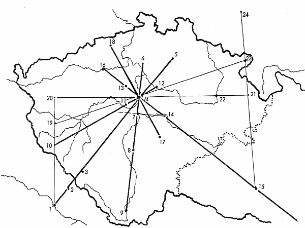
Holy or functional lines over Bohemia (Gerlach): Map 7
 {153}
Map 7: The result of the deliberate and systematic cultural binding of Bohemia and Moravia to the Empire:
1. Nieder-Alteich. 2. Rinchnach 1008. 3. St. Günther’s cell 1045. 4. Břevnov-Prague 993.
5. Mnichovo Hradiště 1054. 6 Chcebus to Břevnov 993. 7. Ostro 999.
8. Milevsko 1184. 9. Zátoň 1040. 10. Domažlice.
11. Svatý Jan pod Skalou (St. John under the Cliff) 1040. 12. Stará Boleslav 1039–1052.
13. Slaný ? 14. Sázava 1032–1039.
15. Rajhrad, priory of Břevnov ? 16. Postoloprty 1110? 17. Louňovice pod Blanikem 1148.
18. Teplice 1146. 19. Kladruby u Stříbra 1108–1115. 20. Teplá 1193.
21. Pěčín, priory of (22) Opatovice 1086. 23. Broumov, priory of Břevnov and
24. Legnickie Pole, priory of Břevnov.
The line drawn over Sázava, perpendicular to the St. Günther axis, continues through Rajhrad as far as Nitra and
Vác.
Back to main text
 {153}
Map 7: The result of the deliberate and systematic cultural binding of Bohemia and Moravia to the Empire:
1. Nieder-Alteich. 2. Rinchnach 1008. 3. St. Günther’s cell 1045. 4. Břevnov-Prague 993.
5. Mnichovo Hradiště 1054. 6 Chcebus to Břevnov 993. 7. Ostro 999.
8. Milevsko 1184. 9. Zátoň 1040. 10. Domažlice.
11. Svatý Jan pod Skalou (St. John under the Cliff) 1040. 12. Stará Boleslav 1039–1052.
13. Slaný ? 14. Sázava 1032–1039.
15. Rajhrad, priory of Břevnov ? 16. Postoloprty 1110? 17. Louňovice pod Blanikem 1148.
18. Teplice 1146. 19. Kladruby u Stříbra 1108–1115. 20. Teplá 1193.
21. Pěčín, priory of (22) Opatovice 1086. 23. Broumov, priory of Břevnov and
24. Legnickie Pole, priory of Břevnov.