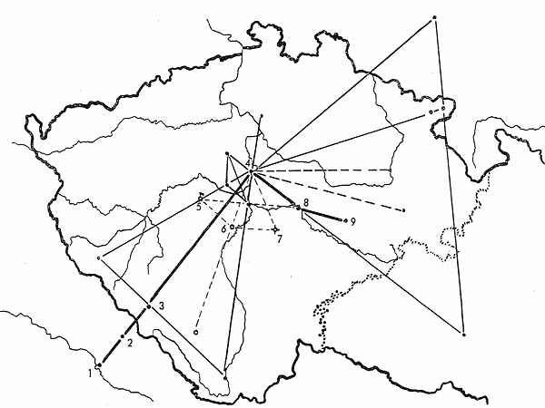
Holy or functional lines over Bohemia (Gerlach): Map 3
 {149}
Map 3: The Thuringian nobleman Günther, an ancestor of the Schwarzburg princes, returns from a journey to Rome in
1008 and in Nieder-Alteich (1), the Bavarian monastery on the Danube downstream from Regensburg, exchanges his
battledress for the cowl of a Benedictine lay-brother. He then founds the hermitage-monastery Rinchnach (2), namely
three cells and a chapel of St. John the Baptist, presses ever deeper into the mountains – as can be seen, in the
direction of Prague – and founds many religious cells, into which he retreats from time to time. The
development/extension of the “Golden Trail”, the old packhorse road from Passau to Prachatice, is said to be
his work. He dies in his cell at Dobrá Voda (near Hartmanice) on St Günther’s Hill (3) and is buried by
Duke Břetislav in Břevnov monastery. The line Nieder-Alteich–Prague passes
though an enigmatic linear network, which is characterized by three place-names and hill-names Žebrák
(beggar) (5, 6, 7) and equal distances of 44 km from Prague and 33 km from one another. In 1032
the hermit Procopius enters the forest solitude on the river Sázava and makes his home in a cave, until in 1039
Duke Břetislav builds the magnificent Sázava monastery there (8). Sázava lies on the line
Prague–Rajhrad, at 44 km from the sacred site in Prague. It later has a priory in Zbýšov, sited
33 km from Sázava.
Back to main text
 {149}
Map 3: The Thuringian nobleman Günther, an ancestor of the Schwarzburg princes, returns from a journey to Rome in
1008 and in Nieder-Alteich (1), the Bavarian monastery on the Danube downstream from Regensburg, exchanges his
battledress for the cowl of a Benedictine lay-brother. He then founds the hermitage-monastery Rinchnach (2), namely
three cells and a chapel of St. John the Baptist, presses ever deeper into the mountains – as can be seen, in the
direction of Prague – and founds many religious cells, into which he retreats from time to time. The
development/extension of the “Golden Trail”, the old packhorse road from Passau to Prachatice, is said to be
his work. He dies in his cell at Dobrá Voda (near Hartmanice) on St Günther’s Hill (3) and is buried by
Duke Břetislav in Břevnov monastery. The line Nieder-Alteich–Prague passes
though an enigmatic linear network, which is characterized by three place-names and hill-names Žebrák
(beggar) (5, 6, 7) and equal distances of 44 km from Prague and 33 km from one another. In 1032
the hermit Procopius enters the forest solitude on the river Sázava and makes his home in a cave, until in 1039
Duke Břetislav builds the magnificent Sázava monastery there (8). Sázava lies on the line
Prague–Rajhrad, at 44 km from the sacred site in Prague. It later has a priory in Zbýšov, sited
33 km from Sázava.